

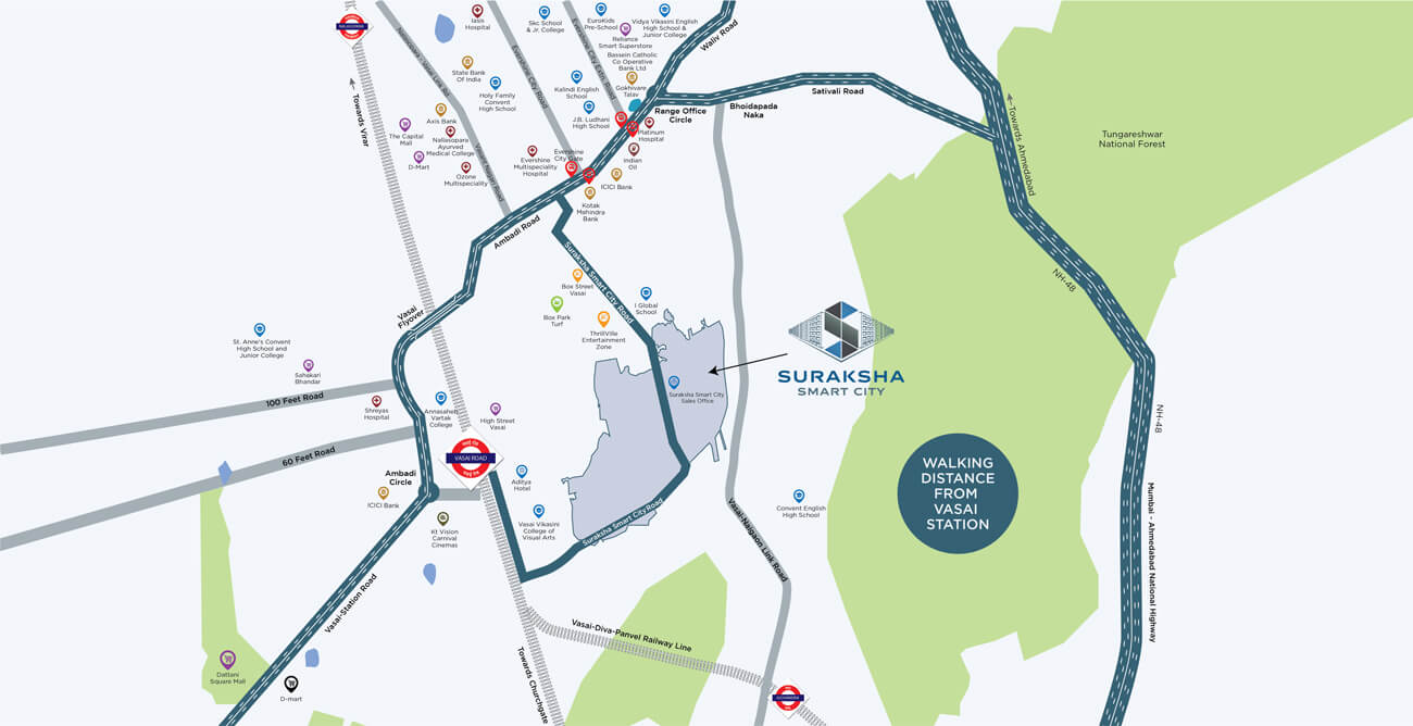
Smart Location
WHERE CONVENIENCE
MEETS COMFORT
SMART INFRASTRUCTURE
INFRASTRUCTURE FOR
A THRIVING SOCIETY
-
I Global School (IGS) School
0.8 km -
Holy Family Convent High School
2.5 kms -
Skc School & Jr. College
3.7 kms -
EuroKids Preschool
3.3 kms -
Vidya Vikasini English High School
3.7 kms
-
Holy Family Convent School & College
2.5 kms -
Vasai Vikasini College of Visual Arts
3.0 kms -
Vartak College
4.3 kms -
Viva College
12.9 kms
-
Evershine Multispeciality Hospital
2 kms -
Iasis Hospital
3 kms -
Ozone Hospital
4.1 kms -
Platinum Hospital
3.1 kms -
Cardinal Gracias Memorial Hospital
8.2 kms
-
DMart
4.3 kms -
The Capital Mall
4.7 kms
SMART CONNECTIVITY
THE FUTURE OF
CONNECTED HOMES
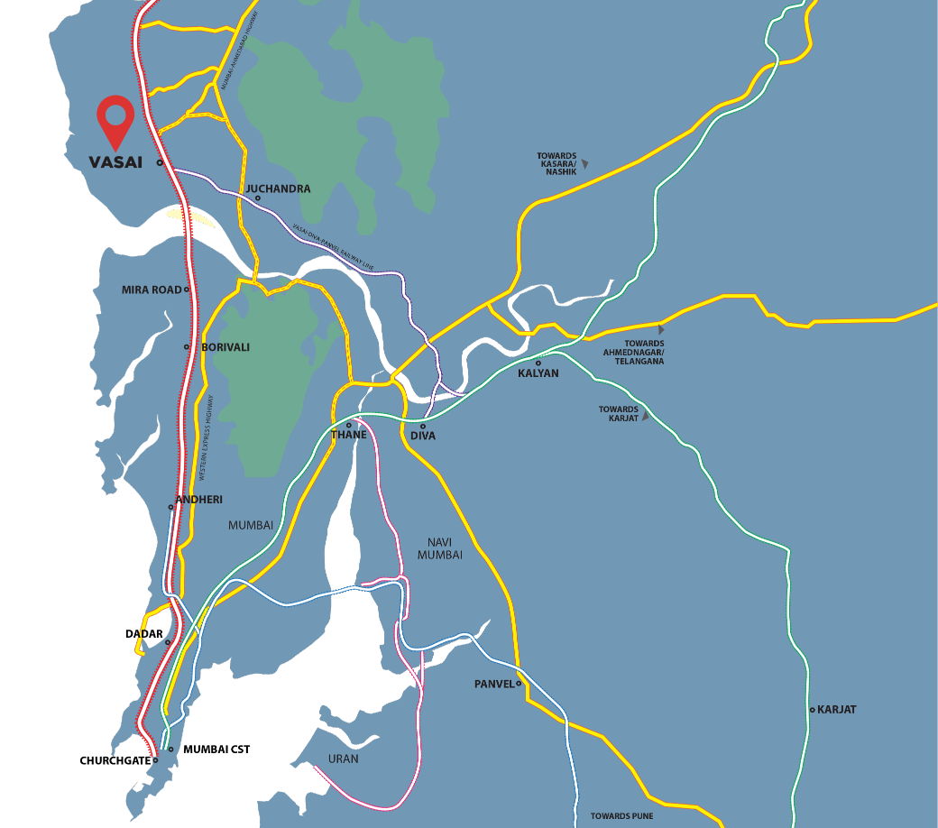
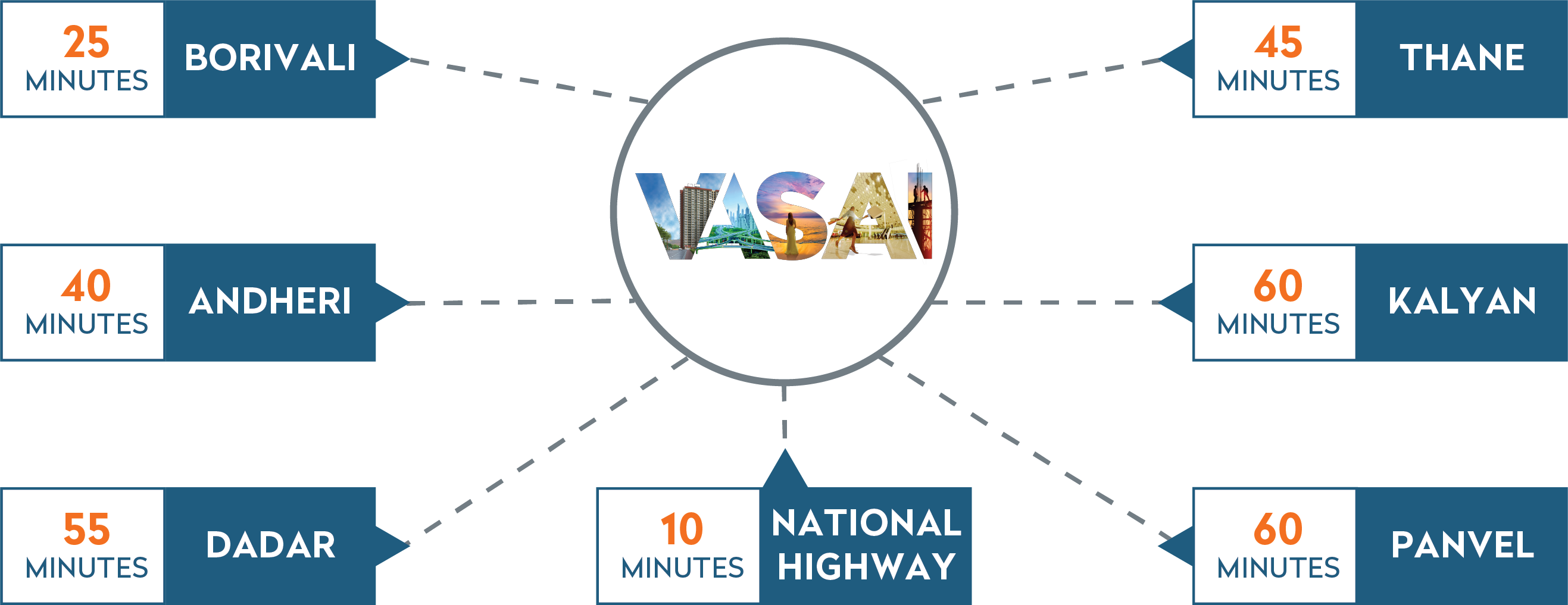
Vasai is a fast-developing area in the Palghar District of Maharashtra. Connectivity is the prime factor that attracts majority of home buyers to this extremely well-planned Mumbai Metropolitan Region. This strategic locale is connected extremely strongly via both, railways and road.
A DESTINATION THAT'S ON A
MULTI-TRACK PATH TO THE FUTURE
MUMBAI-AHMEDABAD
Bullet Train
VASAI-DIVA-PANVEL
Railway Line Extension
VIRAR-ALIBAUG
Multimodal Corridor
DELHI-MUMBAI
Freight Corridor
Mira Road – Virar
Metro Corridor
MUMBAI COASTAL
Road
BHAYANDAR - VASAI
Sea Link
VASAI
Outstation Terminal
BORIVALI - VIRAR
5th & 6th railway line
DAHANU - NASHIK
railway line
Vadhavan
Port
Vadhavan
Airport
REAL ESTATE UPDATES
VASAI IN NEWS
| Headline | Source | Details |
|---|---|---|
| From Peripheral Suburb to Growth Engine: How Vasai is Powering the next Housing Hub with Mumbai 4.0 | Middle Height | Know more |
| From Peripheral Suburb to Growth Engine: How Vasai is Powering the next Housing Hub with Mumbai 4.0 | PNI | Know more |
| Vasai, long viewed as a peripheral suburb, is now gaining traction as a promising housing market. | Projects Mirror | Know more |
| How Vasai is emerging as Mumbai’s fourth growth corridor | Financial Express | Know more |
| Headline | Source | Details |
|---|---|---|
| Vasai set for growth under Fourth Mumbai plan | Prop News Time | Know more |
| Fourth Mumbai’s Role in Transforming Vasai | Realty First | Know more |
| Suraksha Smart City: Redefining Vasai as a Leading Self-Sustained Urban Housing Hub | Mid-Day | Know more |
| Mumbai Beyond Andheri: Where Homebuyers and Investors Are Headed in the Western Suburbs | Realty First | Know more |
| Western Suburbs beyond Andheri gain traction as Mumbai's new residential hotspots | Prop News Time | Know more |
| Strong Growth: Retail Giants Betting Big on Vasai | Edu News | Know more |
| Retail Boom: Why Vasai Is the Next Big Investment Hub | Business News This Week | Know more |
| Vasai’s Rising Market: Retailers Eye Expansion Opportunities | Business News Matters | Know more |
| Affordable Homes, Modern Living: Suraksha Smart City Shapes Vasai’s Tomorrow | Projects Mirror | Know more |
| Union Budget 2025: Affordable housing price cap revision and incentives sought by Suraksha Smart City and Graanth Realty leaders | Business Up Turn | Know more |
| Headline | Source | Details |
|---|---|---|
| Vasai is becoming a key location due to excellent connectivity | Nave Shahar | Know more |
| Versova-Virar Sea Bridge in sight | Maharashtra Times | Know more |
| Vasai-Bhayandar RoRo' starting from Friday | Maharashtra Times | Know more |
| Suburban rly gets fund boost, ₹25,000 crore for bullet train | The Times of India | Know more |
| Why Retailers Are Investing in Vasai? | Projects Mirror | Know more |
| Surya Water Project: A project that will quench MMR's thirst | Maharashtra Times | Know more |
| A new option for fast metro? | Maharashtra Times | Know more |
| Vasai's Changing Landscape: What it means for Savvy investors in the Housing market | Projects Mirror | Know more |
| Rlys plans 6 more terminuses in MMR for 50 new mail trains | Times of India | Know more |